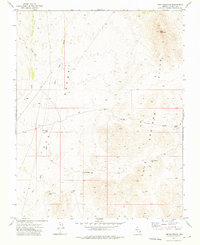
1973 Map of Lime Mountain
USGS Topo · Published 1976About this map
Lime Mountain stands as the primary landmark in this corner of Lincoln County, presiding over a landscape defined by seasonal water drainage and remote high-desert topography. The 1973 survey reveals a territory where survival and land use are dictated by scarce water sources, as seen in the scattered locations of Jones Spring and Snow Spring. The presence of small-scale infrastructure like Sams Camp Res and Middle Pond Res suggests ranching or resource management within the Spring Mountains and Desert Hills.
Find a feature on this map
15 named features on this map. Tap any name to fly to it.
Don’t see what you’re looking for? This feature index may not catch every label — zoom into the map to look around manually.
Map Details
Editions of this 1973 Lime Mountain Map
This is the sole edition of this map. No revisions or reprints were ever made.
Other maps of this area

1885 · Pioche
USGS Topo · 1:250,000

1886 · Pioche
USGS Topo · 1:250,000

1954 · Caliente
USGS Topo · 1:250,000

1959 · Caliente
USGS Topo · 1:250,000
1973 · Jacks Mountain
USGS Topo · 1:24,000
1973 · Tule Spring
USGS Topo · 1:24,000
1973 · Scarecrow Peak
USGS Topo · 1:24,000
1973 · Terry Benches
USGS Topo · 1:24,000
1973 · Toquop Gap
USGS Topo · 1:24,000
1973 · Dodge Spring
USGS Topo · 1:24,000