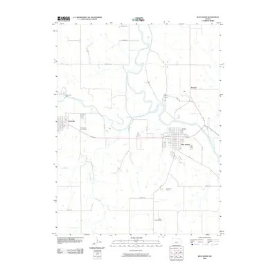
2009 Map of Blue Rapids
USGS Topo · Published 2009About this map
Blue Rapids and Waterville sit at the confluence of major waterways in Marshall County, defined by the winding paths of the Big Blue River and the Little Blue River. The landscape reveals a mix of civic structure and rural utility, with the Waterville Dam and the Waterville Golf Course anchoring the western settlement, while Blue Rapids shows a grid of streets including Gypsum St and Genesee St. Local history is preserved in several significant burial grounds, notably Prospect Hill Cemetery, Fairmont Cemetery, and Greenwood Cemetery, which provide vital touchstones for genealogists. The presence of the Sedivy Landing Strip to the south and the small community of Bestwall to the north highlight the diverse transportation and residential patterns of this Kansas river valley at the end of the first decade of the 2000s.
Find a feature on this map
42 named features on this map. Tap any name to fly to it.
Don’t see what you’re looking for? This feature index may not catch every label — zoom into the map to look around manually.
Map Details
Editions of this 2009 Blue Rapids Map
This is the sole edition of this map. No revisions or reprints were ever made.
Other maps of this area

1889 · Marysville
USGS Topo · 1:125,000

1894 · Marysville
USGS Topo · 1:125,000

1955 · Manhattan
USGS Topo · 1:250,000

1956 · Manhattan
USGS Topo · 1:250,000

1957 · Manhattan
USGS Topo · 1:250,000

1966 · Marysville
USGS Topo · 1:24,000

1966 · Hanover SE
USGS Topo · 1:24,000

1966 · Home
USGS Topo · 1:24,000
1968 · Blue Rapids SE
USGS Topo · 1:24,000
1968 · Blue Rapids NE
USGS Topo · 1:24,000