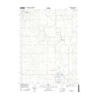
2014 Map of Blue Springs
USGS Topo · Published 2014About this map
The Big Blue River snakes southward through this section of Gage County, anchoring a series of small riverside communities and hydraulic infrastructure. In the northern reaches, the southern edges of Beatrice appear near Crystal Cr, while further downstream, the river passes the Holmesville Power Plant Reservoir and the village of Holmesville. This 2014 survey documents the enduring spatial relationship between the river and the towns of Blue Springs and Wymore, which sit closely together near the Blue Springs Power Plant Reservoir. The landscape is etched with a precise grid of rural roads such as W Lilac Rd and S 10 Rd, connecting several local burial grounds including Saint Marys Cem, Blue Springs Cem, and the Brethren Cem. Tributaries like Bills Cr and Mud Cr dissect the agricultural uplands between the river's winding course.
Find a feature on this map
82 named features on this map. Tap any name to fly to it.
Don’t see what you’re looking for? This feature index may not catch every label — zoom into the map to look around manually.
Map Details
Editions of this 2014 Blue Springs Map
This is the sole edition of this map. No revisions or reprints were ever made.
Other maps of this area

1955 · Lincoln
USGS Topo · 1:250,000

1957 · Lincoln
USGS Topo · 1:250,000

1957 · Beatrice West
USGS Topo · 1:24,000

1957 · Beatrice East
USGS Topo · 1:24,000

1958 · Lincoln
USGS Topo · 1:250,000

1964 · Blue Springs
USGS Topo · 1:24,000

1970 · Diller NE
USGS Topo · 1:24,000
1970 · Wymore
USGS Topo · 1:24,000
1970 · Barneston
USGS Topo · 1:24,000
1970 · Odell
USGS Topo · 1:24,000