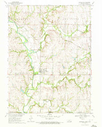
1970 Map of Barneston
USGS Topo · Published 1972About this map
The Big Blue River anchors this 1970s landscape, winding south through the village of Barneston and across the state line toward Gage and Marshall counties. This era shows a community defined by its transport and utility infrastructure, with both the Union Pacific and Burlington Northern railroads traversing the terrain. A notable Powerplant and Gaging Station are situated along the riverbank, while the presence of the Barneston and St. Josephs Cemetery provides a focal point for genealogical interest north of the town center.
Find a feature on this map
23 named features on this map. Tap any name to fly to it.
Don’t see what you’re looking for? This feature index may not catch every label — zoom into the map to look around manually.
Map Details
Editions of this 1970 Barneston Map
This is the sole edition of this map. No revisions or reprints were ever made.
Other maps of this area

1889 · Seneca
USGS Topo · 1:125,000

1889 · Marysville
USGS Topo · 1:125,000

1894 · Seneca
USGS Topo · 1:125,000

1894 · Marysville
USGS Topo · 1:125,000

1955 · Manhattan
USGS Topo · 1:250,000

1955 · Lincoln
USGS Topo · 1:250,000

1956 · Manhattan
USGS Topo · 1:250,000

1957 · Manhattan
USGS Topo · 1:250,000

1957 · Lincoln
USGS Topo · 1:250,000

1958 · Lincoln
USGS Topo · 1:250,000