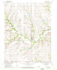
1970 Map of Odell
USGS Topo · Published 1972About this map
The Old Indian Treaty Boundary cuts across the northern landscape of this Gage County and Marshall County border region, where Nebraska meets Kansas. The village of Odell serves as the local hub, established at the junction of the Burlington Northern railroad and several winding watercourses, including Indian Creek and the Big Blue River. This 1970s survey illustrates a rural landscape meticulously divided into townships such as Elm, Sicily, Glenwood, and Paddock. For genealogists, the map is remarkably detailed, locating several distinct community burial grounds including the Czech National Cem, St Josephs Cem, and Reserve Cem. On the southern edge, the settlement of Lanham sits directly on the state line, while infrastructure like the Ash Lake reservoir and various pipelines show the modern modifications to this prairie terrain.
Find a feature on this map
27 named features on this map. Tap any name to fly to it.
Don’t see what you’re looking for? This feature index may not catch every label — zoom into the map to look around manually.
Map Details
Editions of this 1970 Odell Map
This is the sole edition of this map. No revisions or reprints were ever made.
Other maps of this area

1889 · Marysville
USGS Topo · 1:125,000

1894 · Marysville
USGS Topo · 1:125,000

1955 · Manhattan
USGS Topo · 1:250,000

1955 · Lincoln
USGS Topo · 1:250,000

1956 · Manhattan
USGS Topo · 1:250,000

1957 · Manhattan
USGS Topo · 1:250,000

1957 · Lincoln
USGS Topo · 1:250,000

1958 · Lincoln
USGS Topo · 1:250,000

1964 · Blue Springs
USGS Topo · 1:24,000
1966 · Herkimer
USGS Topo · 1:24,000