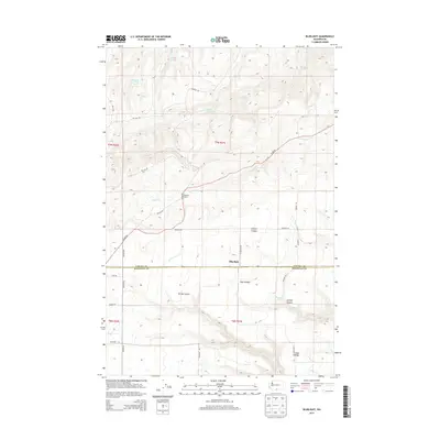
2013 Map of Bluelight
USGS Topo · Published 2013About this map
Bluelight and the Donoho Ranch anchor this landscape along the border of Yakima and Klickitat counties. The terrain is defined by a series of significant drainage systems, including the deeply etched Juniper Canyon, Spring Canyon, and Tule Canyon. Water sources are critical in this high-elevation environment, evidenced by the numerous named springs such as Mammoth Tusk Spring, Bedagound Spring, and Randall Spring that dot the northern reaches. A network of rural roads including Glade Rd and Donoho Rd navigate the ridgelines and creek beds. To the south, Sand Ridge rises above Willow Cr, illustrating the complex topography of this interior Washington region. The distribution of these labels suggests a landscape shaped by ranching and resource management, where named landmarks often center on reliable water points.
Find a feature on this map
34 named features on this map. Tap any name to fly to it.
Don’t see what you’re looking for? This feature index may not catch every label — zoom into the map to look around manually.
Map Details
Editions of this 2013 Bluelight Map
This is the sole edition of this map. No revisions or reprints were ever made.
Other maps of this area

1910 · Zillah
USGS Topo · 1:125,000

1916 · Arlington
USGS Topo · 1:125,000

1950 · Yakima
USGS Topo · 1:250,000

1953 · The Dalles
USGS Topo · 1:250,000

1956 · The Dalles
USGS Topo · 1:250,000

1957 · The Dalles
USGS Topo · 1:250,000

1958 · Yakima
USGS Topo · 1:250,000

1961 · Yakima
USGS Topo · 1:250,000
1962 · Douty Canyon
USGS Topo · 1:24,000
1962 · Crider Valley
USGS Topo · 1:24,000