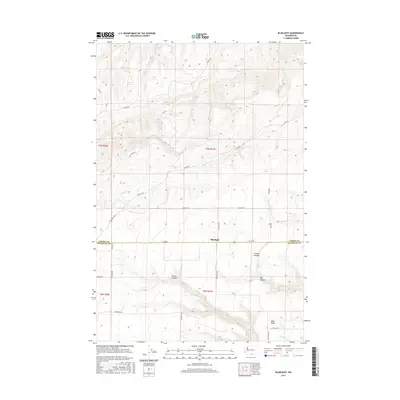
2017 Map of Bluelight
USGS Topo · Published 2017About this map
Bluelight sits at the high-desert boundary of the Yakima Co Klickitat Co line, a landscape defined by its vital water sources and deep seasonal drainages. The area is marked by numerous named water points essential for life in this arid terrain, including Bedground Spring, Mammoth Spring, and Martinet Spring. These features suggest a history of cattle ranching or transit through the high country. The topography is carved by significant canyons such as Juniper Canyon, Tule Canyon, and Spring Canyon, which lead toward the prominent Sand Ridge in the south. Transportation is facilitated by a grid of rural and Bureau of Indian Affairs routes, including BIA Rd 7 and Glade Rd, which navigate the elevation changes near Glade Cr. The map preserves the specific locations of remote springs and the original land divisions of the Public Land Survey System, providing a clear view of how this borderland was managed and utilized in the 21st century.
Find a feature on this map
35 named features on this map. Tap any name to fly to it.
Don’t see what you’re looking for? This feature index may not catch every label — zoom into the map to look around manually.
Map Details
Editions of this 2017 Bluelight Map
This is the sole edition of this map. No revisions or reprints were ever made.
Other maps of this area

1910 · Zillah
USGS Topo · 1:125,000

1916 · Arlington
USGS Topo · 1:125,000

1950 · Yakima
USGS Topo · 1:250,000

1953 · The Dalles
USGS Topo · 1:250,000

1956 · The Dalles
USGS Topo · 1:250,000

1957 · The Dalles
USGS Topo · 1:250,000

1958 · Yakima
USGS Topo · 1:250,000

1961 · Yakima
USGS Topo · 1:250,000
1962 · Douty Canyon
USGS Topo · 1:24,000
1962 · Crider Valley
USGS Topo · 1:24,000