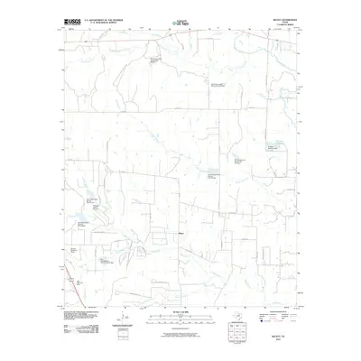
2010 Map of Bluett
USGS Topo · Published 2010About this map
Bluett sits at the heart of this landscape, where the rural character of Wise County is defined by a dense network of watercourses and conservation infrastructure. The area is heavily marked by the work of the Soil Conservation Service, with numerous sites such as Soil Conservation Service Site 24b Dam and Site 31 Dam regulating the flow of local tributaries. These projects support the agricultural and pastoral land surrounding Sweetwater Creek and Oliver Creek, while the Heritage Creek Airstrip and Rhome Meadows Airport provide private aviation access to this part of North Texas. Aviation and water management dominate the topography, which transitions toward the elevated High Mesa and High Mesa Drive. Key water bodies like Duessen Reservoir and Elna Reservoir Dam further illustrate the region's managed hydraulic system at the start of the 21st century.
Find a feature on this map
51 named features on this map. Tap any name to fly to it.
Don’t see what you’re looking for? This feature index may not catch every label — zoom into the map to look around manually.
Map Details
Editions of this 2010 Bluett Map
This is the sole edition of this map. No revisions or reprints were ever made.
Other maps of this area

1924 · Sunset 4-d
USGS Topo · 1:48,000

1930 · Boyd
USGS Topo · 1:62,500

1954 · Sherman
USGS Topo · 1:250,000

1958 · Sherman
USGS Topo · 1:250,000

1959 · Ponder
USGS Topo · 1:24,000

1960 · Decatur
USGS Topo · 1:24,000

1960 · Boyd
USGS Topo · 1:24,000
1960 · Justin
USGS Topo · 1:24,000

1960 · Bluett
USGS Topo · 1:24,000

1960 · Rhome
USGS Topo · 1:24,000