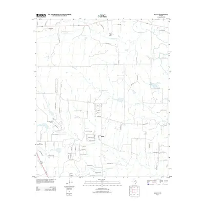
2013 Map of Bluett
USGS Topo · Published 2013About this map
Bluett stands as the central settlement in this portion of Wise County, situated within a landscape deeply carved by a network of seasonal and perennial waterways. This 2013 survey reveals a transition from traditional agricultural land use to specialized aviation, evidenced by the presence of three distinct landing facilities: Allison Farm Airport, Heritage Creek Airstrip, and Rhome Meadows Airport. These private airstrips are scattered among the drainage basins of Sweetwater Cr and Denton Cr in the north, and Oliver Cr in the south. The rural road network, including historical routes like Old Denton Rd, connects various ranch properties such as the Merritt Ranch Rd area. In the east, the Duessen Reservoir provides a significant water source near Deussen Rd, while smaller tributaries like Morris Br and Teeter Br cross the lower elevations between family-named roads like George Foster Rd and Dawssen Rd.
Find a feature on this map
89 named features on this map. Tap any name to fly to it.
Don’t see what you’re looking for? This feature index may not catch every label — zoom into the map to look around manually.
Map Details
Editions of this 2013 Bluett Map
This is the sole edition of this map. No revisions or reprints were ever made.
Other maps of this area

1924 · Sunset 4-d
USGS Topo · 1:48,000

1930 · Boyd
USGS Topo · 1:62,500

1954 · Sherman
USGS Topo · 1:250,000

1958 · Sherman
USGS Topo · 1:250,000

1959 · Ponder
USGS Topo · 1:24,000

1960 · Decatur
USGS Topo · 1:24,000

1960 · Boyd
USGS Topo · 1:24,000
1960 · Justin
USGS Topo · 1:24,000

1960 · Bluett
USGS Topo · 1:24,000

1960 · Rhome
USGS Topo · 1:24,000