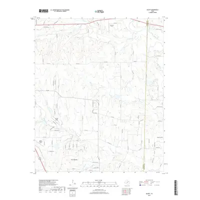
2019 Map of Bluett
USGS Topo · Published 2019About this map
New Fairview serves as the primary settlement on this landscape, which straddles the boundary between Wise Co and Denton Co. The terrain is characterized by a dense network of seasonal and perennial waterways, including Denton Creek, Sweetwater Cr, and Catlett Cr, which carve through the local topography. This area is notably punctuated by several small-scale aviation facilities such as Allison Farm Airport, Rhome Meadows Airport, and Sagebrush Airport, reflecting a post-war pattern of rural private flight and agrarian land use. The presence of Duessen Reservoir and numerous named branches like Morris Br and Teeter Br illustrates a landscape defined by water management and drainage. Near the southern edge, residential development appears along streets like Coyote TRL and Prairie TRL, while the northern portion remains dominated by larger tracts and historical routes like Old Denton Hwy.
Find a feature on this map
85 named features on this map. Tap any name to fly to it.
Don’t see what you’re looking for? This feature index may not catch every label — zoom into the map to look around manually.
Map Details
Editions of this 2019 Bluett Map
This is the sole edition of this map. No revisions or reprints were ever made.
Other maps of this area

1924 · Sunset 4-d
USGS Topo · 1:48,000

1930 · Boyd
USGS Topo · 1:62,500

1954 · Sherman
USGS Topo · 1:250,000

1958 · Sherman
USGS Topo · 1:250,000

1959 · Ponder
USGS Topo · 1:24,000

1960 · Decatur
USGS Topo · 1:24,000

1960 · Boyd
USGS Topo · 1:24,000
1960 · Justin
USGS Topo · 1:24,000

1960 · Bluett
USGS Topo · 1:24,000

1960 · Rhome
USGS Topo · 1:24,000