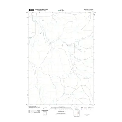
2011 Map of Bluewater
USGS Topo · Published 2011About this map
Bluewater Creek and its complex network of tributaries define the hydrology of this Carbon County landscape. The map reveals an intricate system of water management and natural springs, including O'Connor Ditch, Orchard Ditch, and Big Bluewater Spring, which support the local Bluewater Fish Hatchery. The terrain transitions from the depths of Bachelder Canyon to the seasonal flows of Frosty Jack Creek and Rushwater Creek. Local history is anchored by the Teeples Ranch Cemetery and various family-named landmarks like the Musegades area. This 2011 survey documents a rural environment where land use is dictated by water access, from the high Bachelder Spring to the southern reaches of Cherry Creek and Cherry Springs.
Find a feature on this map
21 named features on this map. Tap any name to fly to it.
Don’t see what you’re looking for? This feature index may not catch every label — zoom into the map to look around manually.
Map Details
Editions of this 2011 Bluewater Map
This is the sole edition of this map. No revisions or reprints were ever made.
Other maps of this area

1954 · Billings
USGS Topo · 1:250,000

1956 · Bridger
USGS Topo · 1:24,000

1956 · Fromberg
USGS Topo · 1:24,000

1956 · Edgar
USGS Topo · 1:24,000

1957 · Billings
USGS Topo · 1:250,000

1958 · Billings
USGS Topo · 1:250,000

1967 · Section House Draw
USGS Topo · 1:24,000

1967 · Bluewater
USGS Topo · 1:24,000
1967 · Pryor NW
USGS Topo · 1:24,000

1969 · Bowler
USGS Topo · 1:24,000