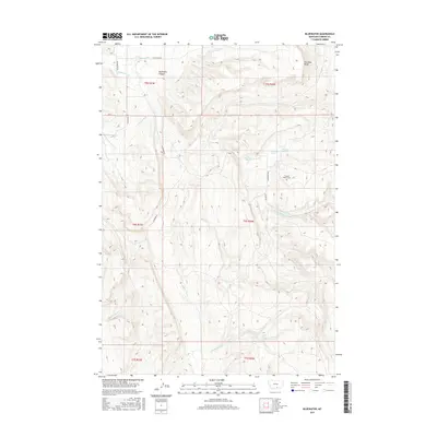
2017 Map of Bluewater
USGS Topo · Published 2017About this map
Bluewater Creek and its complex network of springs and irrigation infrastructure define this landscape in Carbon County. The map details an arid environment where water management is paramount, evidenced by the presence of the O'Connor Ditch and Orchard Ditch. High ground is marked by features like Two Bear Ridge and the deep incision of Bachelder Canyon. For those researching local ranching history, the Teeples Ranch Cem provides a specific genealogical anchor near Prewett Spring. The terrain transitions from these ridges down to numerous named water sources including Big Bluewater Spring, Cherry Springs, and Bachelder Spring, illustrating the vital role of natural aquifers in this part of Montana.
Find a feature on this map
27 named features on this map. Tap any name to fly to it.
Don’t see what you’re looking for? This feature index may not catch every label — zoom into the map to look around manually.
Map Details
Editions of this 2017 Bluewater Map
This is the sole edition of this map. No revisions or reprints were ever made.
Other maps of this area

1954 · Billings
USGS Topo · 1:250,000

1956 · Bridger
USGS Topo · 1:24,000

1956 · Fromberg
USGS Topo · 1:24,000

1956 · Edgar
USGS Topo · 1:24,000

1957 · Billings
USGS Topo · 1:250,000

1958 · Billings
USGS Topo · 1:250,000

1967 · Section House Draw
USGS Topo · 1:24,000

1967 · Bluewater
USGS Topo · 1:24,000
1967 · Pryor NW
USGS Topo · 1:24,000

1969 · Bowler
USGS Topo · 1:24,000