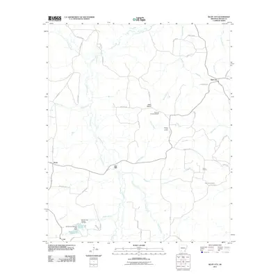
2011 Map of Bluff City
USGS Topo · Published 2011About this map
Bluff City anchors this portion of Nevada County, where the landscape is defined by the headwaters of several drainages, including Caney Creek and Cypress Creek. The area retains its rural character with established smaller settlements like Gum Grove, Morris, and Dills Mills scattered along the local county road network. The presence of the Bluff City State Nursery and several man-made impoundments, such as Barham Lake Number One and Barham Lake Number Two, suggests a managed landscape focused on forestry and water resources. For those tracing family ties in the region, the map identifies specific local landmarks including Gulley Cemetery and Saint Johns Cemetery, which serve as permanent records of the community's history amidst the timber and farmland of southern Arkansas.
Find a feature on this map
49 named features on this map. Tap any name to fly to it.
Don’t see what you’re looking for? This feature index may not catch every label — zoom into the map to look around manually.
Map Details
Editions of this 2011 Bluff City Map
This is the sole edition of this map. No revisions or reprints were ever made.
Other maps of this area

1901 · Gurdon
USGS Topo · 1:125,000

1953 · El Dorado
USGS Topo · 1:250,000

1957 · El Dorado
USGS Topo · 1:250,000

1958 · El Dorado
USGS Topo · 1:250,000

1960 · El Dorado
USGS Topo · 1:250,000

1970 · Whelen Springs
USGS Topo · 1:24,000

1970 · Prescott East
USGS Topo · 1:24,000

1970 · Reader
USGS Topo · 1:24,000
1972 · Gurdon
USGS Topo · 1:62,500
1973 · Chidester
USGS Topo · 1:24,000