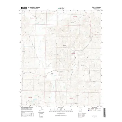
2014 Map of Bluff City
USGS Topo · Published 2014About this map
Bluff City and the small settlements of Gum Grove and Dills Mills anchor this portion of Nevada County, where the landscape is defined by a dense network of creek drainages and small-scale water features. The terrain is deeply carved by Caney Cr and Cypress Cr, which feed into the larger river systems of the region. Local history is preserved in the location of Saint Johns Cem and Gulley Cem, while the southern reaches of the map feature the Barham Lake Number One and Barham Lake Number Two reservoirs. A complex grid of county roads, such as Nevada 408 Rd and Nevada 47 Rd, connects these rural outposts. The map documents a classic Arkansas timberland and agricultural landscape, where the distribution of Morris and Cale reflects the long-standing settlement patterns of the Piney Woods region.
Find a feature on this map
55 named features on this map. Tap any name to fly to it.
Don’t see what you’re looking for? This feature index may not catch every label — zoom into the map to look around manually.
Map Details
Editions of this 2014 Bluff City Map
This is the sole edition of this map. No revisions or reprints were ever made.
Other maps of this area

1901 · Gurdon
USGS Topo · 1:125,000

1953 · El Dorado
USGS Topo · 1:250,000

1957 · El Dorado
USGS Topo · 1:250,000

1958 · El Dorado
USGS Topo · 1:250,000

1960 · El Dorado
USGS Topo · 1:250,000

1970 · Whelen Springs
USGS Topo · 1:24,000

1970 · Prescott East
USGS Topo · 1:24,000

1970 · Reader
USGS Topo · 1:24,000
1972 · Gurdon
USGS Topo · 1:62,500
1973 · Chidester
USGS Topo · 1:24,000