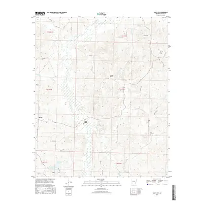
2017 Map of Bluff City
USGS Topo · Published 2017About this map
Bluff City sits at the northeastern edge of this Arkansas landscape, where the local terrain is deeply etched by a network of creeks and branches. This area of Nevada County is defined by its watercourses, including the wide drainage of Caney Cr and the southern reaches of Cypress Cr. Small, established communities like Gum Grove and Dills Mills are connected by a web of county roads, such as Nevada 403 Rd, reflecting a rural settlement pattern that persists into the 21st century. To the south, Barham Lake Number One and Barham Lake Number Two near Cale suggest local water management or recreational resources. For those tracing family histories in the region, the map identifies specific burial sites like Gulley Cem and Saint Johns Cem, providing precise locations for these generational landmarks within the wooded hills and creek valleys.
Find a feature on this map
55 named features on this map. Tap any name to fly to it.
Don’t see what you’re looking for? This feature index may not catch every label — zoom into the map to look around manually.
Map Details
Editions of this 2017 Bluff City Map
This is the sole edition of this map. No revisions or reprints were ever made.
Other maps of this area

1901 · Gurdon
USGS Topo · 1:125,000

1953 · El Dorado
USGS Topo · 1:250,000

1957 · El Dorado
USGS Topo · 1:250,000

1958 · El Dorado
USGS Topo · 1:250,000

1960 · El Dorado
USGS Topo · 1:250,000

1970 · Whelen Springs
USGS Topo · 1:24,000

1970 · Prescott East
USGS Topo · 1:24,000

1970 · Reader
USGS Topo · 1:24,000
1972 · Gurdon
USGS Topo · 1:62,500
1973 · Chidester
USGS Topo · 1:24,000