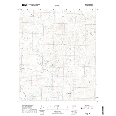
2020 Map of Bluff City
USGS Topo · Published 2020About this map
Bluff City sits at the northeastern corner of this Nevada County landscape, a region defined by the intricate drainages of Caney Cr and its many tributaries. The area's settlement pattern is reflected in a series of small communities and rural intersections such as Gum Grove, Dills Mills, and Morris, many of which are anchored by local family cemeteries. The southern portion of the quadrangle near Cale features the distinct Barham Lake Number 1 and Barham Lake Number Two, providing a contrast to the dense network of creek beds like Meadows Br and Cypress Cr that carve through the terrain. Genealogists will find significant value in the distribution of burial sites, including Ebenezer Cem, Saint Johns Cem, and Hildebrand Cem, which serve as quiet markers of the families who established these small Arkansas outposts.
Find a feature on this map
62 named features on this map. Tap any name to fly to it.
Don’t see what you’re looking for? This feature index may not catch every label — zoom into the map to look around manually.
Map Details
Editions of this 2020 Bluff City Map
This is the sole edition of this map. No revisions or reprints were ever made.
Other maps of this area

1901 · Gurdon
USGS Topo · 1:125,000

1953 · El Dorado
USGS Topo · 1:250,000

1957 · El Dorado
USGS Topo · 1:250,000

1958 · El Dorado
USGS Topo · 1:250,000

1960 · El Dorado
USGS Topo · 1:250,000

1970 · Whelen Springs
USGS Topo · 1:24,000

1970 · Prescott East
USGS Topo · 1:24,000

1970 · Reader
USGS Topo · 1:24,000
1972 · Gurdon
USGS Topo · 1:62,500
1973 · Chidester
USGS Topo · 1:24,000