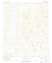
1973 Map of Bluff City
USGS Topo · Published 1975About this map
The Poison Springs State Forest dominates this Arkansas landscape, covering a large portion of the area between the Arkansas-Nevada County line. The community of Bluff City sits in the northeast, supported by infrastructure like the Bluff City State Nursery. The area is defined by its timber and water resources, with numerous creek systems including Little Caney Creek, Goodson Creek, and Cypress Mill Branch draining the undulating terrain. Small rural settlements and family-named locations such as Dills Mills, Morris, and Barham are scattered throughout the quadrangle, connected by the Reader railroad line and roads like the Washington Post Rd. Local genealogy is well-represented through several country churches and burial grounds, including St Johns Ch, Rocky Hill Ch, and the Gulley Cem.
Find a feature on this map
32 named features on this map. Tap any name to fly to it.
Don’t see what you’re looking for? This feature index may not catch every label — zoom into the map to look around manually.
Map Details
Editions of this 1973 Bluff City Map
This is the sole edition of this map. No revisions or reprints were ever made.
Other maps of this area

1901 · Gurdon
USGS Topo · 1:125,000

1953 · El Dorado
USGS Topo · 1:250,000

1957 · El Dorado
USGS Topo · 1:250,000

1958 · El Dorado
USGS Topo · 1:250,000

1960 · El Dorado
USGS Topo · 1:250,000

1970 · Whelen Springs
USGS Topo · 1:24,000

1970 · Prescott East
USGS Topo · 1:24,000

1970 · Reader
USGS Topo · 1:24,000
1972 · Gurdon
USGS Topo · 1:62,500
1973 · Chidester
USGS Topo · 1:24,000