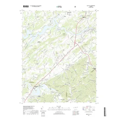
2019 Map of Bluff City
USGS Topo · Published 2019About this map
Boone Lake and the winding course of the Watauga River define this landscape on the border of Sullivan, Washington, and Carter counties. The topography is marked by significant river features such as Indian Bend, Devault Bend, and Hodge Island, which reflect the historic importance of these waterways to local commerce and transport. The dense concentration of family-named cemeteries, including the Geisler-DeVault-Feathers Cem, Arrants Cem, and Mauk Cem, provides a detailed record of the families who settled this corner of East Tennessee. Settlement clusters like Piney Flats, Bluff City, and Buffalo are shown alongside essential infrastructure like the Devault Bridge and the Hyder Bluff Bridge. The presence of the Galloway Mill and several community churches, such as the Buffalo Christian Church Cem, underscores the agrarian and social foundations of the region's rural communities.
Find a feature on this map
111 named features on this map. Tap any name to fly to it.
Don’t see what you’re looking for? This feature index may not catch every label — zoom into the map to look around manually.
Map Details
Editions of this 2019 Bluff City Map
This is the sole edition of this map. No revisions or reprints were ever made.
Other maps of this area

1891 · Roan Mountain
USGS Topo · 1:125,000

1894 · Roan Mountain
USGS Topo · 1:125,000

1897 · Bristol
USGS Topo · 1:125,000

1902 · Bristol
USGS Topo · 1:125,000

1904 · Roan Mountain
USGS Topo · 1:125,000

1934 · Bristol
USGS Topo · 1:24,000

1935 · Watauga Valley
USGS Topo · 1:48,000

1935 · Blountville
USGS Topo · 1:24,000
1935 · Beaver Creek
USGS Topo · 1:48,000

1935 · Spurgeon
USGS Topo · 1:24,000