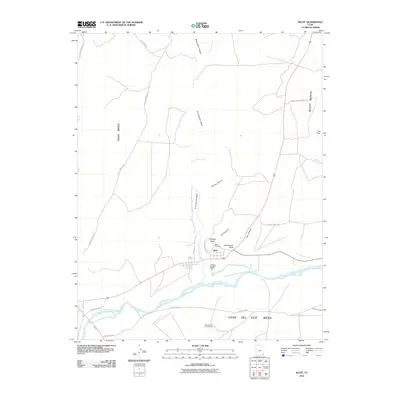
2010 Map of Bluff
USGS Topo · Published 2010About this map
Bluff sits at the northern edge of the San Juan River, established within a dramatic landscape of sandstone formations and high plateaus. The town’s grid is defined by local routes such as 3rd West and Red Rock Rd, leading toward the Bluff Cemetery and distinctive geological landmarks like the Navajo Twins and Sunbonnet Rock. To the north and west, the terrain rises into the broad expanses of Tank Mesa and Bluff Bench, carved by drainage systems including Cottonwood Wash and Spring Canyon. Transport into the backcountry is facilitated by the Butler Wash Rd and its various spurs, while the southern bank of the river is dominated by the massive Casa Del Eco Mesa. This landscape shows a transition from the established riverside settlement to the ancient, high-desert geology that surrounds it.
Find a feature on this map
27 named features on this map. Tap any name to fly to it.
Don’t see what you’re looking for? This feature index may not catch every label — zoom into the map to look around manually.
Map Details
Editions of this 2010 Bluff Map
This is the sole edition of this map. No revisions or reprints were ever made.
Other maps of this area

1886 · Abajo
USGS Topo · 1:250,000

1892 · Abajo
USGS Topo · 1:250,000

1893 · Abajo
USGS Topo · 1:250,000

1956 · Cortez
USGS Topo · 1:250,000

1958 · Cortez
USGS Topo · 1:250,000

1959 · Cortez
USGS Topo · 1:250,000

1962 · Cortez
USGS Topo · 1:250,000
1962 · Bluff NW
USGS Topo · 1:24,000

1962 · Montezuma Creek
USGS Topo · 1:62,500

1962 · Bluff
USGS Topo · 1:62,500