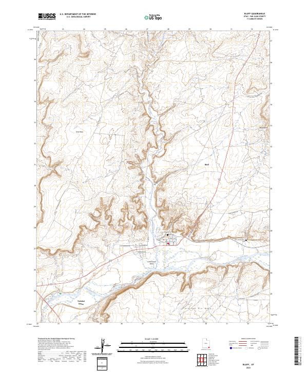
2023 Map of Bluff
USGS Topo · Published 2023About this map
The San Juan River corridor anchors this modern study of the landscape surrounding Bluff, where the river bends sharply against high geological formations. The settlement pattern is defined by the canyon systems and mesas that constrain development to the valley floor. Near the town center, community history is preserved at the Bluff Cem and Saint Christopher's Cem, while further south, the community of Tselakai Dezza sits along the southern bank. The terrain transition is abrupt, moving from the broad expanse of Tank Mesa and Bluff Bench into the deep incisions of Cow Canyon and Calf Canyon. Several seasonal drainage systems, including Cottonwood Wash and Buck Creek, demonstrate the complex hydrography that has shaped this corner of San Juan County. This survey provides an inventory of contemporary infrastructure, from local streets like Mulberry Ave to the reach of Highway 191.
Find a feature on this map
37 named features on this map. Tap any name to fly to it.
Don’t see what you’re looking for? This feature index may not catch every label — zoom into the map to look around manually.
Map Details
Editions of this 2023 Bluff Map
This is the sole edition of this map. No revisions or reprints were ever made.
Other maps of this area

1886 · Abajo
USGS Topo · 1:250,000

1892 · Abajo
USGS Topo · 1:250,000

1893 · Abajo
USGS Topo · 1:250,000

1956 · Cortez
USGS Topo · 1:250,000

1958 · Cortez
USGS Topo · 1:250,000

1959 · Cortez
USGS Topo · 1:250,000

1962 · Cortez
USGS Topo · 1:250,000
1962 · Bluff NW
USGS Topo · 1:24,000

1962 · Montezuma Creek
USGS Topo · 1:62,500

1962 · Bluff
USGS Topo · 1:62,500