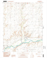
1997 Map of Bluff
USGS Topo · Published 2002About this map
Bluff sits at the base of striking sandstone formations along the northern bank of the San Juan River, representing a landscape where ancient geography meets late 20th-century resource management. The terrain is defined by high plateaus like Tank Mesa and Casa Del Eco Mesa, with the Navajo Indian Reservation extending south across the water. The map documents local landmarks such as the St Christophers Mission and the Navajo Twins rock formations, while also tracking the infrastructure of the era through scattered drill holes, an Oil Well, and the Tank Point Well. This 1997 photo-inspection captures the rural character of San Juan County, showing how the community utilized the natural breaks in the cliffs, like Cow Canyon and Cottonwood Canyon Wash, for transport and settlement.
Find a feature on this map
30 named features on this map. Tap any name to fly to it.
Don’t see what you’re looking for? This feature index may not catch every label — zoom into the map to look around manually.
Map Details
Editions of this 1997 Bluff Map
This is the sole edition of this map. No revisions or reprints were ever made.
Other maps of this area

1886 · Abajo
USGS Topo · 1:250,000

1892 · Abajo
USGS Topo · 1:250,000

1893 · Abajo
USGS Topo · 1:250,000

1956 · Cortez
USGS Topo · 1:250,000

1958 · Cortez
USGS Topo · 1:250,000

1959 · Cortez
USGS Topo · 1:250,000

1962 · Cortez
USGS Topo · 1:250,000
1962 · Bluff NW
USGS Topo · 1:24,000

1962 · Montezuma Creek
USGS Topo · 1:62,500

1962 · Bluff
USGS Topo · 1:62,500