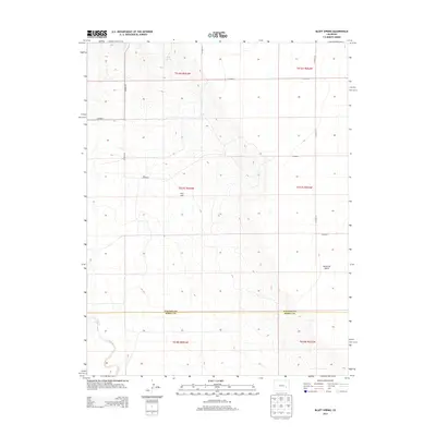
2013 Map of Bluff Spring
USGS Topo · Published 2013About this map
Bluff Spring sits at the northern edge of this high plains landscape, marking a critical water source in an arid stretch of southeastern Colorado. The terrain is defined by wide drainage systems like Maverick Gulch and the headwaters of the Adobe Cr, including its E Fork Adobe Cr. This 2013 survey illustrates the sparse, grid-based development characteristic of the region, where a network of county roads such as Co Road 39 and Co Road 41 provides the only infrastructure across the township lines of Lincoln and Kiowa Counties. Dominating the central landscape is Kim Hill, an isolated topographic rise that serves as a landmark for the surrounding rangeland. The map provides a clear record of the area's transition from Lincoln County into the northern reaches of Kiowa County, preserving the exact layout of rural section lines and local transit routes.
Find a feature on this map
20 named features on this map. Tap any name to fly to it.
Don’t see what you’re looking for? This feature index may not catch every label — zoom into the map to look around manually.
Map Details
Editions of this 2013 Bluff Spring Map
This is the sole edition of this map. No revisions or reprints were ever made.
Other maps of this area

1891 · Arroyo
USGS Topo · 1:125,000

1891 · Las Animas
USGS Topo · 1:125,000

1893 · Arroyo
USGS Topo · 1:125,000

1893 · Las Animas
USGS Topo · 1:125,000

1954 · Lamar
USGS Topo · 1:250,000

1958 · Lamar
USGS Topo · 1:250,000

1974 · Haswell
USGS Topo · 1:24,000

1974 · Arlington NE
USGS Topo · 1:24,000

1978 · Barrel Springs Draw
USGS Topo · 1:24,000
1978 · Galatea SW
USGS Topo · 1:24,000