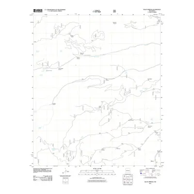
2011 Map of Bluff Springs
USGS Topo · Published 2011About this map
Bluff Springs and the headwaters of the Rio Peñasco anchor this high-altitude landscape in the Sacramento Mountains. The 2011 survey reveals a network of canyons and ridges where water sources like Delworth Spring, Benson Spring, and Hubbell Spring historically dictated movement and land use. The presence of Pine Springs Camp, Camp Wehinahpay, and Skyridge Camp reflects the area's development for youth and recreational camping. Forest Service roads such as Dare Canyon Rd and Upper Rio Penasco Rd navigate the steep terrain, while the Copper Flat Group indicates the history of localized mining interests in the region. Near the southern edge, the terrain descends toward Maxon and the drainage of Agua Chiquita Creek, showing the transition from limestone ridges to narrow canyon floors.
Find a feature on this map
48 named features on this map. Tap any name to fly to it.
Don’t see what you’re looking for? This feature index may not catch every label — zoom into the map to look around manually.
Map Details
Editions of this 2011 Bluff Springs Map
This is the sole edition of this map. No revisions or reprints were ever made.
Other maps of this area

1950 · Escondido Canyon
USGS Topo · 1:62,500

1950 · Alamogordo
USGS Topo · 1:62,500

1952 · Cloudcroft
USGS Topo · 1:62,500

1954 · Carlsbad
USGS Topo · 1:250,000

1958 · Carlsbad
USGS Topo · 1:250,000

1965 · Bear Spring
USGS Topo · 1:24,000

1965 · Rogers Ruins
USGS Topo · 1:24,000
1974 · Sacramento
USGS Topo · 1:24,000
1974 · Bluff Springs
USGS Topo · 1:24,000
1974 · Harvey Ranch
USGS Topo · 1:24,000