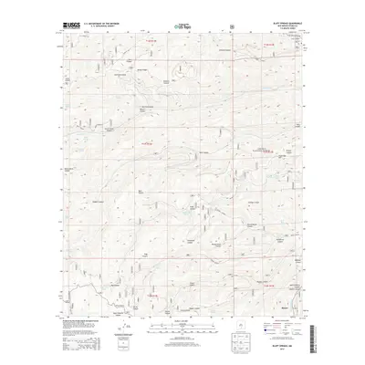
2013 Map of Bluff Springs
USGS Topo · Published 2013About this map
Lincoln National Forest encompasses this high-elevation landscape, where a dense network of canyons and springs defines the local geography. The map reveals a reliance on water sources in this arid environment, naming numerous specific sites such as Masterson Spring, Hubbell Spring, and Delworth Spring. The drainage patterns of Rio Peñasco and Agua Chiquita Cr cut through named landforms like Benson Ridge and Prestridge Hill, illustrating the complex topography of the Sacramento Mountains. In the southern reaches, the settlement of Maxon and the Scott Able Camp provide evidence of human activity and seasonal habitation within the rugged forest boundaries. Transport is primarily limited to forest routes and the Cox Canyon Hwy in the northeast, highlighting the area's isolation and its primary use for ranching, forestry, and recreation.
Find a feature on this map
61 named features on this map. Tap any name to fly to it.
Don’t see what you’re looking for? This feature index may not catch every label — zoom into the map to look around manually.
Map Details
Editions of this 2013 Bluff Springs Map
This is the sole edition of this map. No revisions or reprints were ever made.
Other maps of this area

1950 · Escondido Canyon
USGS Topo · 1:62,500

1950 · Alamogordo
USGS Topo · 1:62,500

1952 · Cloudcroft
USGS Topo · 1:62,500

1954 · Carlsbad
USGS Topo · 1:250,000

1958 · Carlsbad
USGS Topo · 1:250,000

1965 · Bear Spring
USGS Topo · 1:24,000

1965 · Rogers Ruins
USGS Topo · 1:24,000
1974 · Sacramento
USGS Topo · 1:24,000
1974 · Bluff Springs
USGS Topo · 1:24,000
1974 · Harvey Ranch
USGS Topo · 1:24,000