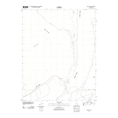
2010 Map of Bluff SW
USGS Topo · Published 2010About this map
Comb Ridge dominates this high-desert landscape in San Juan County, forming a striking geological spine that runs north-to-south. The map details the drainage systems of Comb Wash and Butler Wash, which parallel the ridge and have long served as primary travel corridors through this arid terrain. Access to the interior is defined by a network of backcountry routes, including Snow Flats Rd and Lower Butler Wash Rd, which navigate between prominent elevations like Lime Ridge and Tank Mesa. The presence of the Bluff Airport in the southeastern corner near C R 289A Bluff Airport indicates the modern infrastructure supporting this otherwise remote section of the Colorado Plateau. Several deep-cut drainages, such as Road Canyon, Barton Range Canyon, and Snake Canyon, underscore the intricate erosion patterns characteristic of the region's sandstone topography.
Find a feature on this map
15 named features on this map. Tap any name to fly to it.
Don’t see what you’re looking for? This feature index may not catch every label — zoom into the map to look around manually.
Map Details
Editions of this 2010 Bluff SW Map
This is the sole edition of this map. No revisions or reprints were ever made.
Other maps of this area

1886 · Abajo
USGS Topo · 1:250,000

1892 · Abajo
USGS Topo · 1:250,000

1893 · Abajo
USGS Topo · 1:250,000

1956 · Cortez
USGS Topo · 1:250,000

1958 · Cortez
USGS Topo · 1:250,000

1959 · Cortez
USGS Topo · 1:250,000

1962 · Cortez
USGS Topo · 1:250,000
1962 · Bluff NW
USGS Topo · 1:24,000

1962 · Bluff
USGS Topo · 1:62,500
1962 · Bluff SW
USGS Topo · 1:24,000