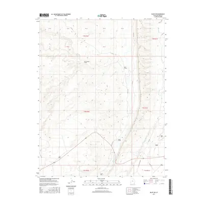
2017 Map of Bluff SW
USGS Topo · Published 2017About this map
Bluff sits at the edge of this high-desert plateau in southern Utah, where the landscape is defined by deep incisions and prominent mesas. The terrain is dominated by the massive Lime Ridge and Tank Mesa, which tower over the surrounding drainage systems. Water, though intermittent, has carved significant paths through the earth, most notably at Butler Wash and Comb Wash. Near the southern edge of the survey, Navajo Spring provides a rare permanent water source amidst the arid expanse.
Find a feature on this map
29 named features on this map. Tap any name to fly to it.
Don’t see what you’re looking for? This feature index may not catch every label — zoom into the map to look around manually.
Map Details
Editions of this 2017 Bluff SW Map
This is the sole edition of this map. No revisions or reprints were ever made.
Other maps of this area

1886 · Abajo
USGS Topo · 1:250,000

1892 · Abajo
USGS Topo · 1:250,000

1893 · Abajo
USGS Topo · 1:250,000

1956 · Cortez
USGS Topo · 1:250,000

1958 · Cortez
USGS Topo · 1:250,000

1959 · Cortez
USGS Topo · 1:250,000

1962 · Cortez
USGS Topo · 1:250,000
1962 · Bluff NW
USGS Topo · 1:24,000

1962 · Bluff
USGS Topo · 1:62,500
1962 · Bluff SW
USGS Topo · 1:24,000