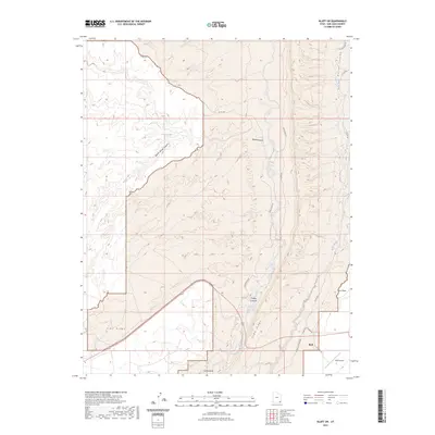
2023 Map of Bluff SW
USGS Topo · Published 2023About this map
The settlement of Bluff anchors the southeastern corner of this modern topographic study, where local roads like CR 269A Bluff Airport and Airport Rd serve the community and the nearby Bluff Airport. The landscape is dominated by dramatic geological structures, most notably the prominent north-south alignment of Comb Ridge and the broad elevation of Lime Ridge to the west. These ridges are carved by an intricate system of drainages, including Butler Wash and Comb Wash, which follow the natural contours of the deep canyon systems.
Find a feature on this map
18 named features on this map. Tap any name to fly to it.
Don’t see what you’re looking for? This feature index may not catch every label — zoom into the map to look around manually.
Map Details
Editions of this 2023 Bluff SW Map
This is the sole edition of this map. No revisions or reprints were ever made.
Other maps of this area

1886 · Abajo
USGS Topo · 1:250,000

1892 · Abajo
USGS Topo · 1:250,000

1893 · Abajo
USGS Topo · 1:250,000

1956 · Cortez
USGS Topo · 1:250,000

1958 · Cortez
USGS Topo · 1:250,000

1959 · Cortez
USGS Topo · 1:250,000

1962 · Cortez
USGS Topo · 1:250,000
1962 · Bluff NW
USGS Topo · 1:24,000

1962 · Bluff
USGS Topo · 1:62,500
1962 · Bluff SW
USGS Topo · 1:24,000