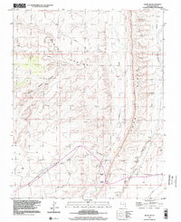
1997 Map of Bluff SW
USGS Topo · Published 2002About this map
Mormon Trail traverses the upper reaches of this high desert landscape, tracing a historic path across the northern section of the map. The terrain is defined by the massive verticality of Comb Ridge, a striking monocline that separates Comb Wash from Butler Wash. This area is dense with archaeological significance, featuring numerous Cliff Dwellings tucked into the alcoves of the canyon walls and along the western face of the ridge. To the southwest, the plateau opens onto Lime Ridge and the Barton Range, where the industrial footprint of the late 20th century appears in the form of several Drill Hole sites and a remote Airstrip. Water sources are vital but scarce, marked by Navajo Spring and a Gaging Station monitoring the seasonal flows of the desert washes.
Find a feature on this map
20 named features on this map. Tap any name to fly to it.
Don’t see what you’re looking for? This feature index may not catch every label — zoom into the map to look around manually.
Map Details
Editions of this 1997 Bluff SW Map
This is the sole edition of this map. No revisions or reprints were ever made.
Other maps of this area

1886 · Abajo
USGS Topo · 1:250,000

1892 · Abajo
USGS Topo · 1:250,000

1893 · Abajo
USGS Topo · 1:250,000

1956 · Cortez
USGS Topo · 1:250,000

1958 · Cortez
USGS Topo · 1:250,000

1959 · Cortez
USGS Topo · 1:250,000

1962 · Cortez
USGS Topo · 1:250,000
1962 · Bluff NW
USGS Topo · 1:24,000

1962 · Bluff
USGS Topo · 1:62,500
1962 · Bluff SW
USGS Topo · 1:24,000