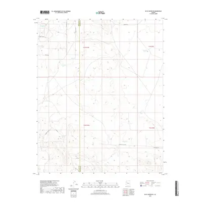
2018 Map of Blye Canyon SE
USGS Topo · Published 2018About this map
The high desert boundary of Mohave County and Yavapai County defines this landscape of scattered water catchments and ranching infrastructure. Central to the local geography are several named reservoirs, including Jim Smith Tanks and Conejo Tank, which serve as vital resources in this arid environment. The map details a network of private and ranch roads, such as Diamond M Ranch Rd and Harris Valley Ranch Rd, that crisscross the terrain to connect remote outposts. While the drainage of Fork Rock Cr cuts through the southern reaches, much of the area is defined by its isolation and the practicalities of high-country land management, seen in features like Old Miller Tank and Old Limestone Tank.
Find a feature on this map
20 named features on this map. Tap any name to fly to it.
Don’t see what you’re looking for? This feature index may not catch every label — zoom into the map to look around manually.
Map Details
Editions of this 2018 Blye Canyon SE Map
This is the sole edition of this map. No revisions or reprints were ever made.
Other maps of this area

1886 · Diamond Creek
USGS Topo · 1:250,000

1892 · Diamond Creek
USGS Topo · 1:250,000

1948 · Williams
USGS Topo · 1:250,000

1954 · Williams
USGS Topo · 1:250,000

1956 · Williams
USGS Topo · 1:250,000

1960 · Williams
USGS Topo · 1:250,000

1961 · Williams
USGS Topo · 1:250,000
1980 · Fort Rock Ranch
USGS Topo · 1:24,000
1980 · Cherokee Point
USGS Topo · 1:24,000
1980 · Cross Mountain
USGS Topo · 1:24,000