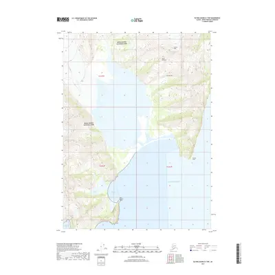
2017 Map of Blying Sound D-7 NW
USGS Topo · Published 2017About this map
Kenai Fjords National Park dominates this coastal survey, where massive ice fields meet the Pacific Ocean. The landscape is defined by the dramatic movement of ice, most notably the sprawling Bear Glacier, which feeds into the water near Bear Glacier Point. This area of the Kenai Peninsula remains largely untouched by modern infrastructure, focusing instead on the dramatic elevation changes from the shoreline to high summits like Callisto Peak.
Find a feature on this map
15 named features on this map. Tap any name to fly to it.
Don’t see what you’re looking for? This feature index may not catch every label — zoom into the map to look around manually.
Map Details
Editions of this 2017 Blying Sound D-7 NW Map
This is the sole edition of this map. No revisions or reprints were ever made.
Other maps of this area

1946 · Blying Sound
USGS Topo · 1:250,000

1950 · Seward A-8
USGS Topo · 1:63,360

1950 · Blying Sound D-7
USGS Topo · 1:63,360

1950 · Seward A-7
USGS Topo · 1:63,360

1951 · Blying Sound
USGS Topo · 1:250,000

1951 · Seward
USGS Topo · 1:250,000

1951 · Seward A-7
USGS Topo · 1:63,360
1951 · Blying Sound D-8
USGS Topo · 1:63,360

1951 · Blying Sound D-7
USGS Topo · 1:63,360

1951 · Seward A-8
USGS Topo · 1:63,360