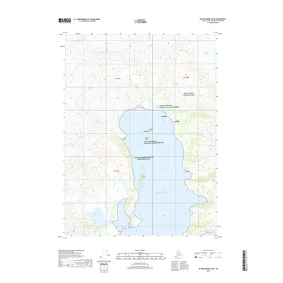
2017 Map of Blying Sound D-8 NE
USGS Topo · Published 2017About this map
Kenai Fjords National Park and the Alaska Maritime National Wildlife Refuge define this coastal landscape on the Kenai Peninsula. The interaction between glacial ice and the Pacific Ocean is the primary geographic feature, with several major ice masses descending toward the water. These include the massive Bear Glacier in the northeast and the Pedersen Glacier and Aialik Glacier to the west. The presence of Skee Glacier, Addison Glacier, and Lechner Glacier further illustrates the high-altitude ice fields that dominate the terrain surrounding the central inlet. Within the water, small landmarks such as Squab Island, Slate Island, and the hazard at Frozen Rock serve as essential navigational markers. The map also records the sheltered waters of Coleman Bay at the southern edge, providing a detailed look at the complex shoreline where the maritime refuge and national park boundaries meet.
Find a feature on this map
18 named features on this map. Tap any name to fly to it.
Don’t see what you’re looking for? This feature index may not catch every label — zoom into the map to look around manually.
Map Details
Editions of this 2017 Blying Sound D-8 NE Map
This is the sole edition of this map. No revisions or reprints were ever made.
Other maps of this area

1946 · Blying Sound
USGS Topo · 1:250,000

1950 · Seward A-8
USGS Topo · 1:63,360

1950 · Blying Sound D-7
USGS Topo · 1:63,360

1950 · Seward A-7
USGS Topo · 1:63,360

1951 · Blying Sound
USGS Topo · 1:250,000

1951 · Seward
USGS Topo · 1:250,000

1951 · Seward A-7
USGS Topo · 1:63,360
1951 · Blying Sound D-8
USGS Topo · 1:63,360

1951 · Blying Sound D-7
USGS Topo · 1:63,360

1951 · Seward A-8
USGS Topo · 1:63,360