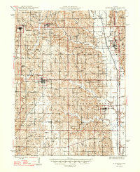
1947 Map of Blythedale
USGS Topo · Published 1947About this map
Chicago Burlington and Quincy rail lines thread through Harrison County's agricultural heartland, connecting rural hubs like Blythedale and Ridgeway during the post-war era. The landscape is defined by a dense network of civic landmarks, including over a dozen neighborhood schools such as Snowball Sch and High Point Sch, which served the scattered farming families of Colfax and Marion townships. In the eastern portion of the survey, the Thompson River and its tributaries like Coal Creek and Trail Creek carve through the terrain, while Yankee Ridge provides a prominent natural divide.
Find a feature on this map
63 named features on this map. Tap any name to fly to it.
Don’t see what you’re looking for? This feature index may not catch every label — zoom into the map to look around manually.
Map Details
Editions of this 1947 Blythedale Map
2 editions found
Other maps of this area

1925 · Pattonsburg
USGS Topo · 1:62,500

1925 · Gilman
USGS Topo · 1:62,500

1944 · Pattonsburg
USGS Topo · 1:62,500

1945 · Mount Ayr
USGS Topo · 1:62,500

1945 · Lamoni
USGS Topo · 1:62,500

1946 · Gilman
USGS Topo · 1:48,000

1946 · Pattonsburg
USGS Topo · 1:48,000

1946 · Princeton
USGS Topo · 1:62,500

1947 · Lamoni
USGS Topo · 1:62,500

1947 · Blythedale
USGS Topo · 1:62,500