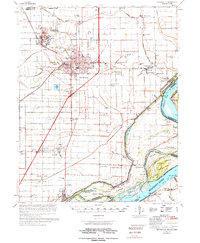
1976 Map of Blytheville
USGS Topo · Published 1976About this map
The sprawling Blytheville Air Force Base dominates the northwestern landscape of this Mississippi County survey, featuring its strategic runway and surrounding facilities near Gosnell. To the southeast, the city of Blytheville serves as the regional hub, connected to outlying agricultural communities like Armorel and Burdette by a network of drainage ditches and the St Louis San Francisco RR. The eastern boundary is defined by the shifting course of the Mississippi River, where river features like Ashport Bend and Forked Deer Island mark the state line with Tennessee.
Find a feature on this map
80 named features on this map. Tap any name to fly to it.
Don’t see what you’re looking for? This feature index may not catch every label — zoom into the map to look around manually.
Map Details
Editions of this 1976 Blytheville Map
This is the sole edition of this map. No revisions or reprints were ever made.
Other maps of this area

1934 · Kennett
USGS Topo · 1:62,500

1939 · Hales Point
USGS Topo · 1:62,500

1939 · Caruthersville
USGS Topo · 1:62,500

1939 · Blytheville
USGS Topo · 1:62,500

1939 · Evadale
USGS Topo · 1:62,500

1940 · Kennett
USGS Topo · 1:62,500

1940 · Hayti
USGS Topo · 1:62,500

1941 · Manila
USGS Topo · 1:62,500

1951 · Caruthersville
USGS Topo · 1:62,500

1952 · Hales Point
USGS Topo · 1:62,500