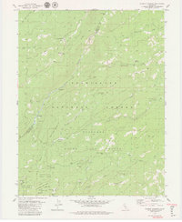
1979 Map of Boards Crossing
USGS Topo · Published 1979About this map
The North Fork Stanislaus River and Beaver Creek carve through this section of the Sierra Nevada, defining a landscape utilized for both timber management and high-country recreation in the late 1970s. The map illustrates the transition between the Calaveras Big Trees State Park and the surrounding Stanislaus National Forest, showing a network of trails and jeep tracks connecting seasonal sites. Notable human imprints include the Ski Lifts at Cottage Springs and the secluded Camp Curry. The presence of several former habitation points, such as Ramsey (Site), Brown Girl Cabin (Site), and Brown Boy Cabin (Site), provides specific coordinates for those tracing the history of early mountain camps and forest service outposts. The survey also captures local landmarks like Boards Crossing and the prominent Summit Level Ridge.
Find a feature on this map
39 named features on this map. Tap any name to fly to it.
Don’t see what you’re looking for? This feature index may not catch every label — zoom into the map to look around manually.
Map Details
Editions of this 1979 Boards Crossing Map
2 editions found

Other maps of this area

1891 · Big Trees
USGS Topo · 1:125,000

1894 · Big Trees
USGS Topo · 1:125,000

1897 · Big Trees
USGS Topo · 1:125,000

1901 · Big Trees
USGS Topo · 1:125,000

1947 · Sacramento
USGS Topo · 1:250,000

1948 · Sacramento
USGS Topo · 1:250,000

1948 · Columbia
USGS Topo · 1:62,500

1948 · Stanislaus
USGS Topo · 1:24,000
1949 · Stanislaus
USGS Topo · 1:24,000

1956 · Sacramento
USGS Topo · 1:250,000