
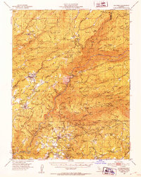
1979 Map of Boards Crossing
USGS Topo · Published 1979About this map
Cottage Springs serves as a central point of activity in this high-elevation landscape, where the recreation and timber heritage of the Sierra Nevada is clearly visible. The terrain is defined by the deep carving of the North Fork Stanislaus River, with numerous tributaries such as Beaver Creek and Griswold Creek feeding the watershed. Evidence of the region's seasonal and specialized habitation is found in the scattered camps and cabin sites, including Whittles Upper Camp and the curiously named Brown Girl Cabin (Site) and Brown Boy Cabin (Site). Large portions of the territory fall under the management of the Stanislaus National Forest and the Calaveras Big Trees State Park, highlighting the long-standing conservation efforts for the area's giant sequoias. Navigational landmarks like Summit Level Ridge and Windy Gap provide orientation for those traversing the network of trails and jeep paths that crisscross the backcountry.
Find a feature on this map
42 named features on this map. Tap any name to fly to it.
Don’t see what you’re looking for? This feature index may not catch every label — zoom into the map to look around manually.
Map Details
Editions of this 1979 Boards Crossing Map
2 editions found

Other maps of this area

1891 · Big Trees
USGS Topo · 1:125,000

1894 · Big Trees
USGS Topo · 1:125,000

1897 · Big Trees
USGS Topo · 1:125,000

1901 · Big Trees
USGS Topo · 1:125,000

1947 · Sacramento
USGS Topo · 1:250,000

1948 · Sacramento
USGS Topo · 1:250,000
1948 · Columbia
USGS Topo · 1:62,500
1948 · Stanislaus
USGS Topo · 1:24,000

1949 · Stanislaus
USGS Topo · 1:24,000

1956 · Sacramento
USGS Topo · 1:250,000