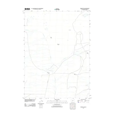
2012 Map of Boars Tusk
USGS Topo · Published 2012About this map
Boars Tusk serves as the namesake landmark for this Sweetwater County landscape, defined by a network of seasonal drainages and local ranching history. The map documents the arid terrain surrounding Killpecker Cr and Nitch Cr, where water management was vital for survival and commerce. Features like Fifteenmile Knoll Reservoir near Fifteenmile Knoll illustrate the importance of surface water collection in this part of Wyoming. To the north, the Lewis Ranch stands as a focal point of settlement, while natural breaks in the elevation appear at Deer Canyon and Pine Canyon. Along the western edge, Chilton Rd provides the primary transit route through a region characterized by prominent rises such as Matthews Hill.
Find a feature on this map
10 named features on this map. Tap any name to fly to it.
Don’t see what you’re looking for? This feature index may not catch every label — zoom into the map to look around manually.
Map Details
Editions of this 2012 Boars Tusk Map
This is the sole edition of this map. No revisions or reprints were ever made.
Other maps of this area

1954 · Rock Springs
USGS Topo · 1:250,000

1955 · Lander
USGS Topo · 1:250,000

1958 · Lander
USGS Topo · 1:250,000

1958 · Rock Springs
USGS Topo · 1:250,000

1958 · Essex Mountain
USGS Topo · 1:62,500

1958 · Boars Tusk
USGS Topo · 1:62,500

1961 · Lander
USGS Topo · 1:250,000

1962 · Rock Springs
USGS Topo · 1:250,000

1968 · White Rocks
USGS Topo · 1:24,000
1968 · Clay Buttes SE
USGS Topo · 1:24,000