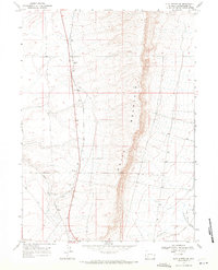
1968 Map of Clay Buttes SE
USGS Topo · Published 1971About this map
The dramatic escarpment of White Mountain dominates the landscape of Sweetwater County in this late 1960s survey. The map details a high-desert environment where drainage patterns like Alkali Creek and the deep incision of Killpecker Canyon define the topography east of the mountain's crest. Industrial activity is evident in the southeastern corner, where the U S Steel R R cuts across the basin near Fourteenmile Creek. This specialized rail line and the presence of several Borrow Pit excavations indicate the area's mid-century role in supporting regional mining and infrastructure. The map serves as a precise record of the transport corridors and geological features that shaped this portion of the Wyoming plateau during a period of industrial expansion.
Find a feature on this map
7 named features on this map. Tap any name to fly to it.
Don’t see what you’re looking for? This feature index may not catch every label — zoom into the map to look around manually.
Map Details
Editions of this 1968 Clay Buttes SE Map
This is the sole edition of this map. No revisions or reprints were ever made.
Other maps of this area

1908 · Rock Springs
USGS Topo · 1:62,500

1910 · Rock Springs
USGS Topo · 1:62,500

1954 · Rock Springs
USGS Topo · 1:250,000

1958 · Rock Springs
USGS Topo · 1:250,000

1958 · Boars Tusk
USGS Topo · 1:62,500

1961 · Scott Spring
USGS Topo · 1:24,000

1961 · Pilot Butte
USGS Topo · 1:24,000

1962 · Rock Springs
USGS Topo · 1:250,000

1968 · Clay Buttes
USGS Topo · 1:24,000

1968 · White Rocks
USGS Topo · 1:24,000