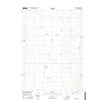
2015 Map of Boars Tusk
USGS Topo · Published 2015About this map
Boars Tusk rises as a prominent landmark in this high-desert landscape of Sweetwater County, anchoring a terrain defined by volcanic features and expansive drainage systems. The 2015 survey reveals a network of intermittent waterways including Killpecker Cr and Nitch Cr that carve through the arid topography. Human footprint in this area is primarily represented by long-distance ranch roads like Chilton Ranch Rd and Chilton Rd, which navigate around landforms such as Matthews Hill and Fifteenmile Knoll. The presence of the Fifteenmile Knoll Reservoir suggests the importance of water management for livestock in this open range. This map captures the remote character of the Wyoming interior, where geographic features like Deer Canyon and Pine Canyon provide the primary orientation points for travelers and ranchers alike.
Find a feature on this map
16 named features on this map. Tap any name to fly to it.
Don’t see what you’re looking for? This feature index may not catch every label — zoom into the map to look around manually.
Map Details
Editions of this 2015 Boars Tusk Map
This is the sole edition of this map. No revisions or reprints were ever made.
Other maps of this area

1954 · Rock Springs
USGS Topo · 1:250,000

1955 · Lander
USGS Topo · 1:250,000

1958 · Lander
USGS Topo · 1:250,000

1958 · Rock Springs
USGS Topo · 1:250,000

1958 · Essex Mountain
USGS Topo · 1:62,500

1958 · Boars Tusk
USGS Topo · 1:62,500

1961 · Lander
USGS Topo · 1:250,000

1962 · Rock Springs
USGS Topo · 1:250,000

1968 · White Rocks
USGS Topo · 1:24,000
1968 · Clay Buttes SE
USGS Topo · 1:24,000