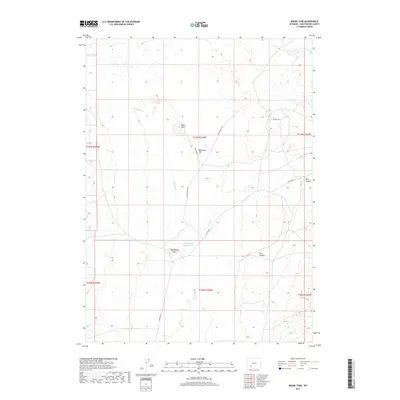
2017 Map of Boars Tusk
USGS Topo · Published 2017About this map
Boars Tusk, a prominent volcanic neck, serves as the defining landmark of this Sweetwater County landscape. The high desert terrain is punctuated by significant relief, including Matthews Hill and Fifteenmile Knoll, which rise above the surrounding drainage basins. Water management in this arid environment is evidenced by the Fifteenmile Knoll Reservoir, while seasonal flows are tracked through the courses of Killpecker Cr and Nitch Cr. Transport through the region is largely limited to the path of Chilton Rd, which navigates between the topographic breaks of Pine Canyon and Deer Canyon. The map provides a detailed view of the Bureau of Land Management's public land survey system, illustrating the townships and ranges that define local land administration in the late 2010s.
Find a feature on this map
15 named features on this map. Tap any name to fly to it.
Don’t see what you’re looking for? This feature index may not catch every label — zoom into the map to look around manually.
Map Details
Editions of this 2017 Boars Tusk Map
This is the sole edition of this map. No revisions or reprints were ever made.
Other maps of this area

1954 · Rock Springs
USGS Topo · 1:250,000

1955 · Lander
USGS Topo · 1:250,000

1958 · Lander
USGS Topo · 1:250,000

1958 · Rock Springs
USGS Topo · 1:250,000

1958 · Essex Mountain
USGS Topo · 1:62,500

1958 · Boars Tusk
USGS Topo · 1:62,500

1961 · Lander
USGS Topo · 1:250,000

1962 · Rock Springs
USGS Topo · 1:250,000

1968 · White Rocks
USGS Topo · 1:24,000
1968 · Clay Buttes SE
USGS Topo · 1:24,000