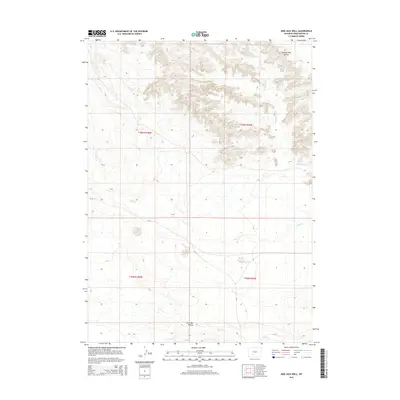
2015 Map of Bob Jack Well
USGS Topo · Published 2015About this map
Honeycomb Buttes dominate the high ground in the northeastern corner of this Sweetwater County landscape, where elevation changes are marked by intricate contouring across a series of ridges and draws. This arid terrain is defined by its drainage patterns, notably the path of Bear Cr and its tributary N Fork Bear Cr as they navigate the southern reaches. The presence of Little Bar Draw and Bush Cr further south illustrates the network of intermittent waterways essential to this high desert environment. Human activity is sparse and primarily limited to transportation corridors like CR-74, which provides access across the various survey sections. The map preserves the exact boundaries of the Public Land Survey System, including t26n r100w and t26n r99w, which remain foundational for land ownership and cattle ranching history in this part of Wyoming.
Find a feature on this map
10 named features on this map. Tap any name to fly to it.
Don’t see what you’re looking for? This feature index may not catch every label — zoom into the map to look around manually.
Map Details
Editions of this 2015 Bob Jack Well Map
This is the sole edition of this map. No revisions or reprints were ever made.
Other maps of this area

1955 · Lander
USGS Topo · 1:250,000

1958 · Lander
USGS Topo · 1:250,000

1958 · Circle Bar Lake
USGS Topo · 1:24,000

1958 · Freighter Gap
USGS Topo · 1:62,500

1958 · The Pinnacles
USGS Topo · 1:62,500

1958 · Dickie Springs
USGS Topo · 1:24,000

1958 · Continental Peak
USGS Topo · 1:24,000

1961 · Lander
USGS Topo · 1:250,000
1984 · South Pass
USGS Topo · 1:100,000
1986 · Joe Hay Rim
USGS Topo · 1:24,000