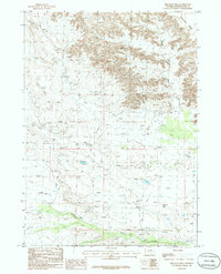
1986 Map of Bob Jack Well
USGS Topo · Published 1986About this map
The Honeycomb Buttes dominate the northeastern corner of this Sweetwater County landscape, transitioning into a vast network of drainage basins and ephemeral water sources. The namesake Bob Jack Well is located in the southeastern quadrant, representing a critical water point for ranching operations in this arid region of the state. The terrain is defined by the convergence of the North Fork Bear Creek and the main channel of Bear Creek, which meander through a series of draws including the Little Bar X Draw. An isolated Landing Strip near the southern boundary suggests the reliance on light aircraft for transport and land management during the mid-1980s. The map further documents numerous Springs and seasonal features like Dry Lake and Bush Creek, providing a detailed record of water resources and topography before significant modern developments.
Find a feature on this map
11 named features on this map. Tap any name to fly to it.
Don’t see what you’re looking for? This feature index may not catch every label — zoom into the map to look around manually.
Map Details
Editions of this 1986 Bob Jack Well Map
This is the sole edition of this map. No revisions or reprints were ever made.
Other maps of this area

1955 · Lander
USGS Topo · 1:250,000

1958 · Lander
USGS Topo · 1:250,000

1958 · Circle Bar Lake
USGS Topo · 1:24,000

1958 · Freighter Gap
USGS Topo · 1:62,500

1958 · The Pinnacles
USGS Topo · 1:62,500

1958 · Dickie Springs
USGS Topo · 1:24,000

1958 · Continental Peak
USGS Topo · 1:24,000

1961 · Lander
USGS Topo · 1:250,000
1984 · South Pass
USGS Topo · 1:100,000
1986 · Joe Hay Rim
USGS Topo · 1:24,000