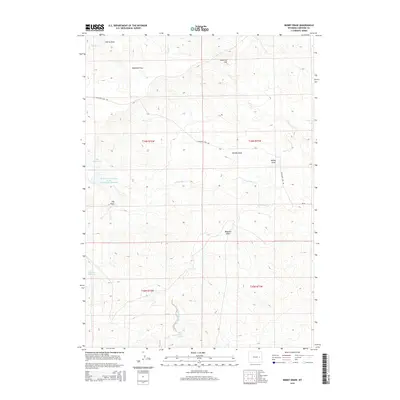
2015 Map of Bobby Draw
USGS Topo · Published 2015About this map
Highland Flats and the surrounding high plains of Converse County are defined by a complex network of seasonal drainages and ranching infrastructure. This landscape is marked by the presence of industrial water management, notably the Enlargement Tailings Basin Evaporation Reservoir, which suggests nearby mineral extraction or processing activities. Traditional cattle ranching continues at sites like the Clausen Ranch and Sundquist Ranch, which rely on vital water sources such as Red Rock Spring and several man-made impoundments including Morton Reservoir and Doe Reservoir. The terrain is characterized by numerous draws, including Gumbo Draw, Bowman Draw, and the namesake Bobby Draw. Transportation across these flats is facilitated primarily by Highland Loop Rd, which connects the various ranching and industrial parcels in this corner of Wyoming.
Find a feature on this map
24 named features on this map. Tap any name to fly to it.
Don’t see what you’re looking for? This feature index may not catch every label — zoom into the map to look around manually.
Map Details
Editions of this 2015 Bobby Draw Map
This is the sole edition of this map. No revisions or reprints were ever made.
Other maps of this area

1949 · Sundquist Ranch
USGS Topo · 1:24,000

1949 · Gilbert Lake
USGS Topo · 1:24,000

1949 · Clausen Ranch
USGS Topo · 1:24,000

1950 · Clausen Ranch
USGS Topo · 1:24,000

1950 · Gilbert Lake
USGS Topo · 1:24,000
1950 · Sundquist Ranch
USGS Topo · 1:24,000

1954 · Torrington
USGS Topo · 1:250,000

1955 · Newcastle
USGS Topo · 1:250,000

1958 · Torrington
USGS Topo · 1:250,000

1958 · Newcastle
USGS Topo · 1:250,000