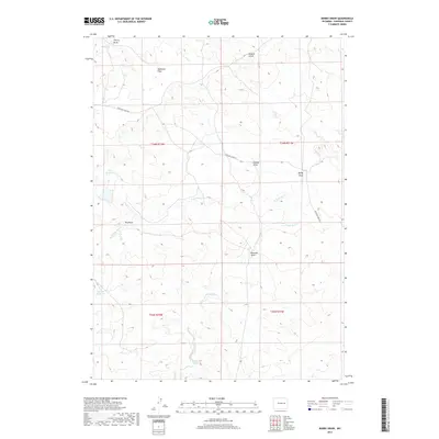
2017 Map of Bobby Draw
USGS Topo · Published 2017About this map
Highland Flats and the elevated terrain of Nine-H-6 Hill define this corner of Converse County, where the landscape is etched by a complex network of seasonal drainages. The Highland Loop Rd serves as the primary artery through this high-plains environment, connecting remote ranching terrain across the townships of T36N and T35N. The importance of water management in this arid region is evident through features like Doe Reservoir and Morton Reservoir, which capture runoff from the various draws. A diverse nomenclature of local drainages, including Bobby Draw, Gumbo Draw, and Bowman Draw, alongside Red Rock Spring, provides a detailed look at how the early inhabitants and surveyors identified the specific folds and water sources of the Wyoming backcountry.
Find a feature on this map
20 named features on this map. Tap any name to fly to it.
Don’t see what you’re looking for? This feature index may not catch every label — zoom into the map to look around manually.
Map Details
Editions of this 2017 Bobby Draw Map
This is the sole edition of this map. No revisions or reprints were ever made.
Other maps of this area

1949 · Sundquist Ranch
USGS Topo · 1:24,000

1949 · Gilbert Lake
USGS Topo · 1:24,000

1949 · Clausen Ranch
USGS Topo · 1:24,000

1950 · Clausen Ranch
USGS Topo · 1:24,000

1950 · Gilbert Lake
USGS Topo · 1:24,000
1950 · Sundquist Ranch
USGS Topo · 1:24,000

1954 · Torrington
USGS Topo · 1:250,000

1955 · Newcastle
USGS Topo · 1:250,000

1958 · Torrington
USGS Topo · 1:250,000

1958 · Newcastle
USGS Topo · 1:250,000