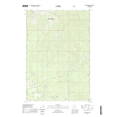
2020 Map of Bobs Mountain
USGS Topo · Published 2020About this map
The Gifford Pinchot National Forest dominates this landscape, where the Washougal River and the W Fork Washougal River carve through high-elevation terrain. In the western portion of the map, the high peaks of Silver Star Mtn and Little Baldy stand near the Indian Pits, a site of cultural and archaeological significance. Lower in the drainage, the Camp Kwoneesum Dam sits along Wildboy Cr, while the small settlement of Bear Prairie provides a anchor for the rural road network in the southwest corner. The transition from industrial timber land to protected forest is evident in the dense network of forest roads such as Federal Rd 1200 and State Forest Rd. Recreational and utilitarian features like Dougan Falls, Washougal Ponds, and the Sky River Ranch Airport dot the lower elevations, reflecting the modern use of this drainage near the Skamania and Clark County border.
Find a feature on this map
73 named features on this map. Tap any name to fly to it.
Don’t see what you’re looking for? This feature index may not catch every label — zoom into the map to look around manually.
Map Details
Editions of this 2020 Bobs Mountain Map
This is the sole edition of this map. No revisions or reprints were ever made.
Other maps of this area

1918 · Troutdale
USGS Topo · 1:62,500

1934 · Troutdale
USGS Topo · 1:48,000

1940 · Lookout Mtn
USGS Topo · 1:62,500

1941 · Yacolt
USGS Topo · 1:62,500

1941 · Camas
USGS Topo · 1:62,500

1942 · Camas
USGS Topo · 1:62,500

1948 · Vancouver
USGS Topo · 1:250,000

1950 · Vancouver
USGS Topo · 1:250,000

1950 · Vancouver
USGS Topo · 1:250,000

1953 · Lookout Mtn
USGS Topo · 1:62,500