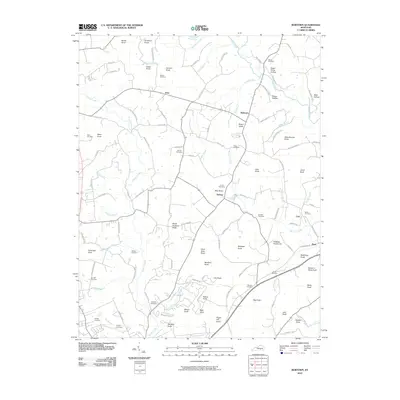
2010 Map of Bobtown
USGS Topo · Published 2010About this map
Bobtown and the rural communities of northern Pulaski County are defined by a densely corrugated landscape of named knobs and winding creek branches. This 2010 survey illustrates the persistent agricultural and residential patterns of the region, where settlements like Etna and Dabney are linked by a network of narrow roads following the ridgelines and valley floors. The distribution of family burial grounds, including the Surber Cemetery, Mercer Cemetery, and Sowder Cemetery, points to the deep generational ties of the local population. Distinctive landmarks such as Peach Orchard Knob and Jingling Hole Knob break the horizon, while waterways like Pitman Creek and Buck Creek drain the uneven terrain. The map records the contemporary footprint of these communities just as digital mapping standards were being refined by the U.S. Geological Survey.
Find a feature on this map
123 named features on this map. Tap any name to fly to it.
Don’t see what you’re looking for? This feature index may not catch every label — zoom into the map to look around manually.
Map Details
Editions of this 2010 Bobtown Map
This is the sole edition of this map. No revisions or reprints were ever made.
Other maps of this area

1893 · London
USGS Topo · 1:125,000

1897 · London
USGS Topo · 1:125,000

1935 · Somerset
USGS Topo · 1:62,500

1952 · Eubank
USGS Topo · 1:24,000

1952 · Dykes
USGS Topo · 1:24,000

1952 · Shopville
USGS Topo · 1:24,000

1952 · Woodstock
USGS Topo · 1:24,000

1953 · Maretburg
USGS Topo · 1:24,000
1954 · Bobtown
USGS Topo · 1:24,000

1954 · Delmer
USGS Topo · 1:24,000