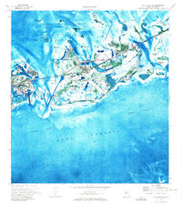
1971 Map of Boca Chica Key
USGS Topo · Published 1973About this map
The U.S. Naval Air Station Key West dominates the central landscape of Boca Chica Key, showing the strategic military infrastructure of the Florida Keys in the early 1970s. This orthophotomat merges traditional topographic lines with aerial photography, revealing the intricate patterns of mangroves and shallow channels surrounding Big Coppitt Key and the Saddlebunch Keys. To the north, the protected waters of the Great White Heron National Wildlife Refuge contrast with the developing institutional corridor along Roosevelt Blvd, which includes the Florida Keys Community College and Lower Keys Memorial Hospital. Local recreation and entertainment are visible through the Key West Country Club and a Drive-in Theater near Stock Island. Navigational markers and sounding depths define the Intracoastal Waterway and Hawk Channel, illustrating the critical maritime connections between the Gulf and the Atlantic.
Find a feature on this map
57 named features on this map. Tap any name to fly to it.
Don’t see what you’re looking for? This feature index may not catch every label — zoom into the map to look around manually.
Map Details
Editions of this 1971 Boca Chica Key Map
This is the sole edition of this map. No revisions or reprints were ever made.
Other maps of this area

1921 · Sugar Loaf Key
USGS Topo · 1:62,500

1921 · Key West
USGS Topo · 1:62,500

1943 · Bay Keys
USGS Topo · 1:24,000

1943 · Saddlebunch Keys
USGS Topo · 1:24,000

1943 · Boca Chica
USGS Topo · 1:24,000

1943 · Key West
USGS Topo · 1:24,000

1943 · Snipe Keys
USGS Topo · 1:24,000

1943 · Sugarloaf Key
USGS Topo · 1:24,000

1962 · Key West
USGS Topo · 1:24,000

1968 · Saddlebunch Keys
USGS Topo · 1:24,000