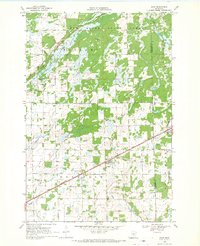
1968 Map of Bock
USGS Topo · Published 1970About this map
Bock serves as the central hub of this 1968 survey, situated along the diagonal corridor of the Great Northern railroad. The landscape is defined by its extensive drainage network, where the Rum River and its numerous tributaries like Mike Brook and Bogus Brook carve through the glacial terrain. Much of the northern territory is protected within the Rum River State Forest, while the southern half reflects the rural township development of Borgholm. Local history and genealogy interest is found in the scattered markers of early community life, including the Borgholm Cem and School No 1156. The map captures a moment when the regional economy still heavily relied on the rails and small-scale resource extraction, evidenced by numerous Gravel Pits distributed across the prairie and wetlands.
Find a feature on this map
16 named features on this map. Tap any name to fly to it.
Don’t see what you’re looking for? This feature index may not catch every label — zoom into the map to look around manually.
Map Details
Editions of this 1968 Bock Map
2 editions found
Other maps of this area

1953 · Stillwater
USGS Topo · 1:250,000

1955 · Stillwater
USGS Topo · 1:250,000

1958 · Stillwater
USGS Topo · 1:250,000

1961 · Dalbo
USGS Topo · 1:24,000

1961 · Dalbo
USGS Topo · 1:62,500

1965 · Stillwater
USGS Topo · 1:250,000

1968 · Milaca NE
USGS Topo · 1:24,000

1968 · Ann Lake
USGS Topo · 1:24,000

1968 · Milaca
USGS Topo · 1:24,000
1968 · Page
USGS Topo · 1:24,000