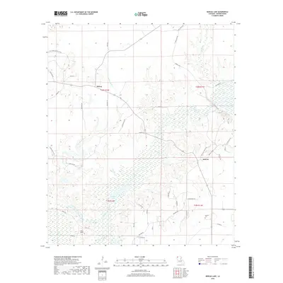
2018 Map of Bodcau Lake
USGS Topo · Published 2018About this map
Dry Cypress Bayou and the winding reaches of Bodcau Cr define the low-lying terrain of Bossier Parish in this 2018 survey. The small settlement of Bellevue serves as a focal point for the local road network, which includes Linton Bellevue Rd and Bellevue Cemetery Rd. The landscape is a complex mix of wetlands and wooded uplands, punctuated by small communities like Midway and Dean Point. Genealogists and local historians will find the location of Hawkins Cem particularly useful, situated east of Bodcau Lake. The area reflects a rural Louisiana character where hunting and outdoor recreation are prominent, as evidenced by Seven Pines Hunting Club Rd. The map also captures the intricate drainage patterns of the Tidwell Br and the various loops of the Bodcau Creek system, illustrating the seasonal hydrology of the region.
Find a feature on this map
47 named features on this map. Tap any name to fly to it.
Don’t see what you’re looking for? This feature index may not catch every label — zoom into the map to look around manually.
Map Details
Editions of this 2018 Bodcau Lake Map
This is the sole edition of this map. No revisions or reprints were ever made.
Other maps of this area

1922 · Sarepta
USGS Topo · 1:62,500

1924 · Sarepta
USGS Topo · 1:62,500

1932 · Bossier SE
USGS Topo · 1:31,680

1932 · Bossier NE
USGS Topo · 1:31,680

1932 · Bossier SW
USGS Topo · 1:31,680

1932 · Bossier NW
USGS Topo · 1:31,680

1947 · Minden
USGS Topo · 1:62,500

1948 · Bossier City
USGS Topo · 1:62,500

1949 · Minden
USGS Topo · 1:62,500

1950 · Plain Dealing SW
USGS Topo · 1:31,680