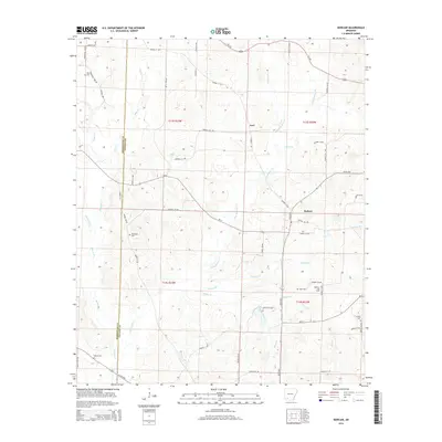
2014 Map of Bodcaw
USGS Topo · Published 2014About this map
Bodcaw and the small settlement of Azor anchor this landscape along the border of Nevada and Hempstead counties. The terrain is defined by a dense network of tributaries including Bodcau Cr, Little Bodcau Cr, and Whitten Br, which carve through the low-lying hills of southwestern Arkansas. This era reveals a mix of traditional agricultural land and modern industry, specifically the Bodcaw Oil Field located in the eastern portion of the quadrangle. Genealogists will find a significant distribution of family and community burial grounds across the area, from Ebenezer Cem in the west to Dunn Cem and Corinth Cem near the oil field. The rural infrastructure is maintained by a grid of numbered roads like AR 53 Hwy and Nevada 11 Rd, connecting dispersed homesteads and marking the long-standing township and range boundaries of the region.
Find a feature on this map
60 named features on this map. Tap any name to fly to it.
Don’t see what you’re looking for? This feature index may not catch every label — zoom into the map to look around manually.
Map Details
Editions of this 2014 Bodcaw Map
This is the sole edition of this map. No revisions or reprints were ever made.
Other maps of this area

1901 · Gurdon
USGS Topo · 1:125,000

1951 · Patmos
USGS Topo · 1:24,000

1951 · Hope
USGS Topo · 1:24,000

1952 · Old Town
USGS Topo · 1:24,000

1953 · El Dorado
USGS Topo · 1:250,000

1957 · El Dorado
USGS Topo · 1:250,000

1958 · El Dorado
USGS Topo · 1:250,000

1960 · El Dorado
USGS Topo · 1:250,000

1968 · Lamartine
USGS Topo · 1:24,000
1968 · Falcon
USGS Topo · 1:24,000