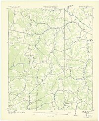
1936 Map of Bodenham
USGS Topo · Published 1936About this map
The Lawrence Co Giles Co line bisects this 1936 survey, showcasing a rural landscape defined by narrow creek valleys and a dense network of country schools and churches. This field examination, conducted for the Tennessee Valley Authority, records a community reliant on the local hubs of Bodenham and Shore. The distribution of educational and religious sites is particularly notable, with Chestnut Grove Sch, Springdale Sch, and Copperas Sch serving families living along the many hollows like Johnson Hollow and Randolph Hollow.
Find a feature on this map
49 named features on this map. Tap any name to fly to it.
Don’t see what you’re looking for? This feature index may not catch every label — zoom into the map to look around manually.
Map Details
Editions of this 1936 Bodenham Map
2 editions found
Other maps of this area

1936 · Milky Way
USGS Topo · 1:24,000

1936 · Aspen Hill
USGS Topo · 1:24,000

1936 · Campbellsville
USGS Topo · 1:24,000

1936 · Lawrenceburg
USGS Topo · 1:24,000

1936 · Ethridge
USGS Topo · 1:24,000

1936 · Pulaski
USGS Topo · 1:24,000

1936 · Bodenham
USGS Topo · 1:24,000

1936 · Appleton
USGS Topo · 1:24,000

1936 · Bonnertown
USGS Topo · 1:24,000
1948 · Appleton
USGS Topo · 1:24,000